Grímsvötn eruption last year (May 21, 2011)
I must write of last Friday morning as I've never seen a professor so passionate and into what they were teaching us, it felt like a news broadcast. He loves volcanoes, especially, and grew up near one in Iceland. It was great! He is a world--renowned Volcanologist, Sigurdur Reynir Gislason, who researches presently with 11 PhD students in this field specifically in Iceland. They know within 45 minutes of each volcanic eruption when it'll go and are straight on their way or already there when it happens, sampling the water in front of glacial floods or sediment/asi sampling, etc and other research they're doing. I learned so much yet will try to condense it here. Basically, rocks control the atmosphere as they fixate the Carbon just as vegetation does. When an eruption occurs, CO2 is spewed out naturally continuing the C cycle. Depending on the magma's viscosity and whether it is basaltic, etc. and gas pressure determines what kind of eruption it is.
8500 years ago, the tree line was much higher in Iceland. In times of glaciation, the weight of glacial ice weighs the continent down, isostatically, and as the glaciers melt the continent moves up again. This is all recorded in the layers of rock & soils. Three more recent eruptions in Iceland were quite interesting (hope I got my facts straight but this comes from my notes):
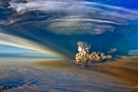
1. Grímsvötn volcano, SE Iceland (Vatnajokull glacier covers it): (May 21, 2011) Was the largest eruption in 50 yrs in Iceland. lifted the glacial ice so dramatically that in seconds it was the 2nd largest river in the world (Amazon's discharge is 200,000 m3/s and this flood was instantly from zero to 50,000 m3/s discharge!) That's a wall of water larger than a house with 180 Million tons of suspended solids heading to the ocean which has a major effect on the sea. i.e. a flood of Fe (iron) can cause a fertilizing bloom in the ocean. A 50 km path formed in 24 hrs.
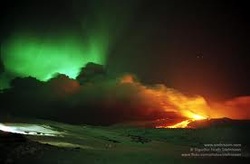
2. Eyjafjallajökull volcano/glacier, South Iceland (April 14, 2010) This eruption caused a the largest interuption in air traffic since world War II, when over 100,000 flights were cancelled in Europe for 7 days. This is because the melting pt of ash is 1100-1200 degrees C and the engine of the airplane melts the ash at 2000 degree C, then cools particles fast as it resolidifies it stops the engines. Iceland was mostly not affected as the 9-km high tephra ash drifted south away from the island. The scientific team at the University of Iceland, incl my professor(s) were out sampling the very fine ash It is so dark that they can't see their arm in front of them in the middle of the day! The lava fell down a 200m drop at Eyjafjallajokull, beside
Mt Katla (also thought to be possible for eruption 'soon' but who knows?!?) where students were sampling downstream. Quite an exciting event!
3. Mt. Hekla South Iceland (erupted in 2000), 1991 & 1981) is one of Iceland's most active volcanoes, erupting about once every decade and may be due for an eruption as it raised about 1 m indicating magma under the surface. Hekla has no glacier covering it so the eruptions are less explosive.
There is on average one volcanic eruption every 1-2 years for quite awhile, and about 5 earthquakes a day measuring usually 2.0 magnitude. They are to the central and east side of Iceland mostly. Since 1958, about 658 sq. km of glacier has retreated on Iceland, yet it's a natural process and it's estimated Iceland's had over 30 glaciations in the past. Vatnajokull is the largest glacier in Europe at 8000 sq. km, which it's volcano last erupted in 1996. The 1362 eruption of Öræfajökull was historic and the Heimay eruption in 1973 added 2 sq. km to Iceland! Quite a phenomenom. There is an area to the NE of Iceland that is in exploration stages for oil, otherwise there is no oil to speak of because it's so geologically young and mostly made of basalt.
In a new class, Geochemical Analysis, we are learning how to sample geothermal waters out in the field near geysirs, mud pots, glaciers and volcanoes. The pH of water can go from 10 down to 2 depending on how much Sulfur & other elements are in the rocks which creates sulfuric acid. We go on a 3-day field trip at the end of Sept and thankfully mom will be here to be with the children while I go trampsing around sampling who knows what!
8500 years ago, the tree line was much higher in Iceland. In times of glaciation, the weight of glacial ice weighs the continent down, isostatically, and as the glaciers melt the continent moves up again. This is all recorded in the layers of rock & soils. Three more recent eruptions in Iceland were quite interesting (hope I got my facts straight but this comes from my notes):
1. Grímsvötn volcano, SE Iceland (Vatnajokull glacier covers it): (May 21, 2011) Was the largest eruption in 50 yrs in Iceland. lifted the glacial ice so dramatically that in seconds it was the 2nd largest river in the world (Amazon's discharge is 200,000 m3/s and this flood was instantly from zero to 50,000 m3/s discharge!) That's a wall of water larger than a house with 180 Million tons of suspended solids heading to the ocean which has a major effect on the sea. i.e. a flood of Fe (iron) can cause a fertilizing bloom in the ocean. A 50 km path formed in 24 hrs.
2. Eyjafjallajökull volcano/glacier, South Iceland (April 14, 2010) This eruption caused a the largest interuption in air traffic since world War II, when over 100,000 flights were cancelled in Europe for 7 days. This is because the melting pt of ash is 1100-1200 degrees C and the engine of the airplane melts the ash at 2000 degree C, then cools particles fast as it resolidifies it stops the engines. Iceland was mostly not affected as the 9-km high tephra ash drifted south away from the island. The scientific team at the University of Iceland, incl my professor(s) were out sampling the very fine ash It is so dark that they can't see their arm in front of them in the middle of the day! The lava fell down a 200m drop at Eyjafjallajokull, beside
Mt Katla (also thought to be possible for eruption 'soon' but who knows?!?) where students were sampling downstream. Quite an exciting event!
3. Mt. Hekla South Iceland (erupted in 2000), 1991 & 1981) is one of Iceland's most active volcanoes, erupting about once every decade and may be due for an eruption as it raised about 1 m indicating magma under the surface. Hekla has no glacier covering it so the eruptions are less explosive.
There is on average one volcanic eruption every 1-2 years for quite awhile, and about 5 earthquakes a day measuring usually 2.0 magnitude. They are to the central and east side of Iceland mostly. Since 1958, about 658 sq. km of glacier has retreated on Iceland, yet it's a natural process and it's estimated Iceland's had over 30 glaciations in the past. Vatnajokull is the largest glacier in Europe at 8000 sq. km, which it's volcano last erupted in 1996. The 1362 eruption of Öræfajökull was historic and the Heimay eruption in 1973 added 2 sq. km to Iceland! Quite a phenomenom. There is an area to the NE of Iceland that is in exploration stages for oil, otherwise there is no oil to speak of because it's so geologically young and mostly made of basalt.
In a new class, Geochemical Analysis, we are learning how to sample geothermal waters out in the field near geysirs, mud pots, glaciers and volcanoes. The pH of water can go from 10 down to 2 depending on how much Sulfur & other elements are in the rocks which creates sulfuric acid. We go on a 3-day field trip at the end of Sept and thankfully mom will be here to be with the children while I go trampsing around sampling who knows what!
 RSS Feed
